
Introduction
Agricultural drones, also called unmanned aerial systems (UAS), are compact aircraft equipped with multispectral, thermal, and RGB sensors that capture real‑time crop reflectance, soil‑moisture, and topographic data. Within minutes they can produce field‑scale maps that guide precise irrigation, fertilizer, and pest‑management decisions. Their ability to spray 10–25 acres per hour, reach steep or wet terrain, and keep workers out of direct contact with chemicals makes them indispensable for modern, data‑driven farming. This article explores how drones enable rapid monitoring, targeted input application, and faster damage assessment, while also addressing regulatory requirements, economic impacts, and future technology trends that together shape the scope of precision agriculture.
Real‑Time Crop Monitoring and Data Analytics
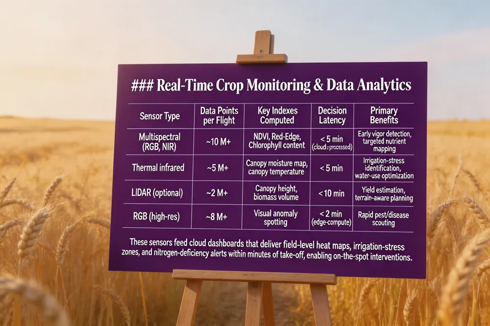 Modern agricultural UAVs (UAS) are equipped with passive and active sensors that capture multispectral, thermal, and RGB imagery across visible, mid‑infrared, and thermal wavelengths. These sensors generate millions of data points per flight, which are streamed via cellular or satellite links to cloud‑based platforms. In the cloud, algorithms instantly compute indices such as NDVI for vegetation vigor, thermal moisture maps, and reflectance‑based nutrient deficiency metrics. The processed results populate farmer‑focused dashboards that display field‑level heat maps, irrigation‑stress zones, and nitrogen‑deficiency alerts within minutes of take‑off. Because the data are refreshed on demand, growers can make immediate, data‑driven decisions—adjusting irrigation schedules, applying spot‑treatments of fertilizer or pesticide, and reallocating resources to under‑performing zones. This rapid feedback loop reduces chemical waste, improves water use efficiency, and shortens the response time from days (satellite) to minutes (drone), delivering a true real‑time precision‑agriculture workflow.
Precision Irrigation and Water Management
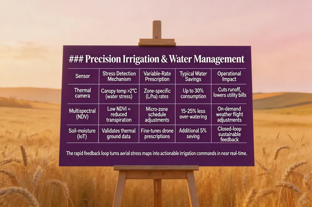 Thermal and multispectral sensors mounted on agricultural drones can spot subtle temperature differences that indicate water stress long before wilting becomes visible. By flying a drone over a field and collecting thermal imagery, farmers receive a heat‑map that highlights zones where plants are losing moisture, allowing immediate corrective action. The cloud‑based analytics that receive these data can translate the stress map into variable‑rate irrigation prescriptions, automatically adjusting water delivery rates for each micro‑zone. This precision approach directs water only where it is needed, cutting overall consumption by up to 30 % and dramatically reducing runoff and waste. Because drone flights can be performed on demand within minutes, irrigation managers can respond to changing weather or soil conditions in near real‑time, improving moisture efficiency across the entire acreage. The result is a more sustainable water budget, lower utility costs, and healthier crops that benefit from consistently optimal hydration.
Targeted Nutrient and Pest Management
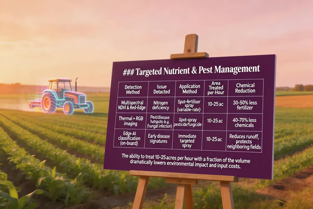 Agricultural drones equipped with multispectral and infrared sensors capture precise reflectance signatures that reveal nitrogen deficiencies long before visual symptoms appear. By analyzing the normalized difference vegetation index (NDVI) and other spectral indices, growers can pinpoint under‑fertilized zones and apply nitrogen only where it is needed, cutting fertilizer waste and reducing runoff. The same sensor suite guides spot‑spraying of pests and diseases: drones fly pre‑programmed flight paths, detect stress hotspots in real time, and dispense pesticides or fungicides only on the affected plants. This precision application can treat 10‑25 acres per hour while using a fraction of the chemical volume of conventional broadcast spraying, dramatically lowering the amount of pesticide that reaches waterways or neighboring fields. The result is a measurable reduction in chemical runoff, minimized environmental impact, and cost savings for the farmer. Moreover, the rapid, on‑demand data delivery to cloud‑based decision platforms enables growers to act immediately, turning early stress detection into timely, targeted interventions that support sustainable intensification.
Mechanical Tasks: Spraying, Seeding, and Fertiliser Application
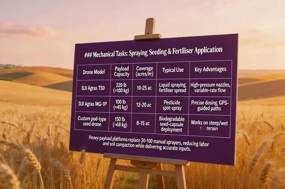 Modern agricultural drones can carry payloads up to 220 lb (≈ 100 kg), allowing them to transport two sacks of fertilizer, a full tank of pesticide, or a large seed‑pod dispenser in a single flight. These heavy‑payload platforms, such as the DJI Agras T50 and its 100‑kg‑class siblings, can spray between 10 and 25 acres per hour—roughly the labor of 30‑100 manual sprayers—by using high‑pressure nozzles and variable‑rate technology that adjusts flow in real time. In addition to traditional liquid spraying, emerging drone designs are equipped with pod‑type seed dispensers that fire biodegradable seed capsules and combine fertilizer granules directly into the soil, enabling precise cover‑crop planting even on steep or wet terrain where tractors cannot operate. This combination of high payload capacity, rapid coverage, and innovative seed‑pod or fertilizer‑distribution systems is driving a shift toward more efficient, lower‑impact mechanical tasks on farms worldwide.
Regulatory Landscape in the United States and Ireland
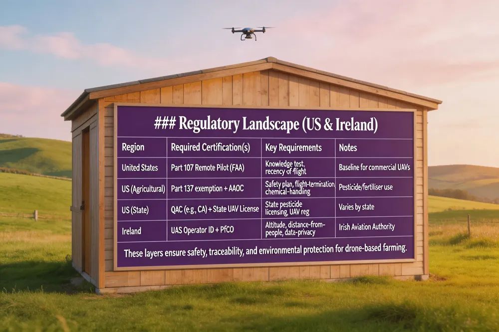 In the United States, any commercial agricultural drone operation first requires a Part 107 Remote Pilot Certificate, which is obtained after passing the FAA knowledge test and meeting recency‑of‑flight requirements. For pesticide or fertilizer dispensing, operators must also secure a Part 137 agricultural exemption and an Agricultural Aircraft Operator Certificate (AAOC) which involve detailed safety plans, a flight‑termination system, and coordination with an FAA Air Traffic Organization. Ireland follows the EU‑wide drone framework administered by the Irish Aviation Authority (IAA). All UAVs over 250 g must be registered, and pilots need a competency certificate (the IAA’s “UAS Operator ID”) before they can obtain a Permission for Commercial Operations (PfCO) for agricultural work. The PfCO confirms compliance with altitude, distance‑from‑people, and data‑privacy rules. State‑level pesticide licensing still applies: for example, California requires a Qualified Applicator Certificate (QAC) and a DPR‑issued Unmanned Apprentice Pilot Certificate (APC) for restricted‑use chemicals, while other U.S. states have equivalent applicator licences. Together, these layers ensure safety, traceability, and environmental protection for drone‑based farming.
Economic Impact and Market Growth
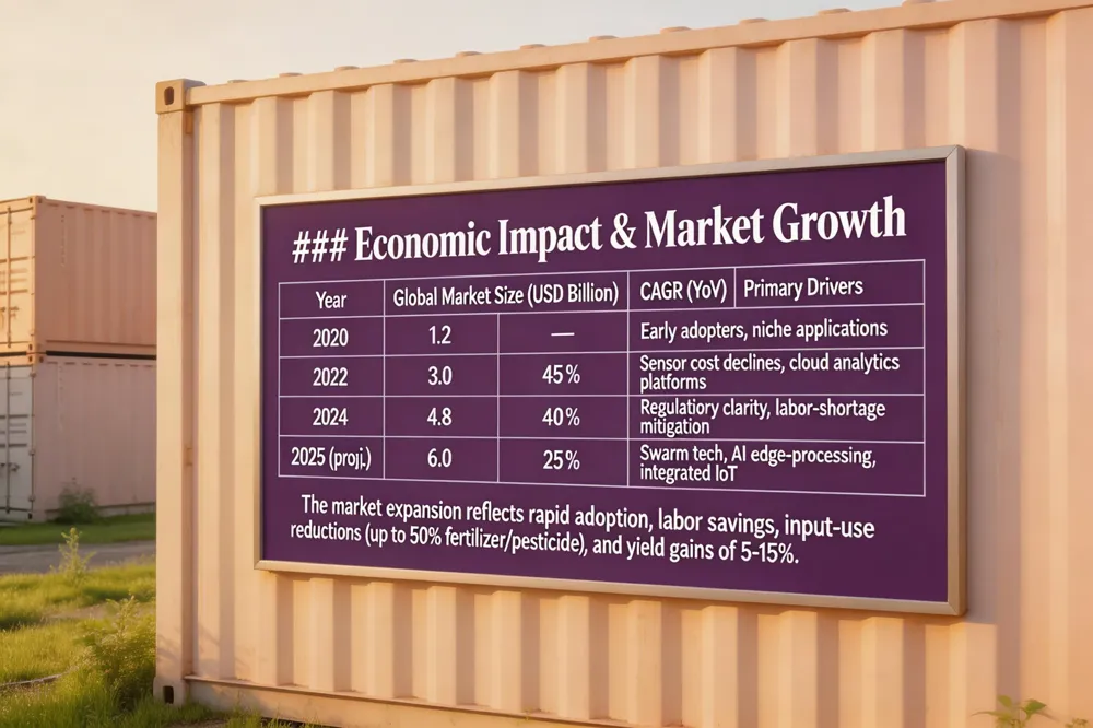 The global agricultural‑drone market is on a rapid ascent, expanding from $1.2 billion in 2020 to an estimated $6 billion by 2025. This growth is reflected domestically: U.S. FAA registrations for farm‑use UAVs climbed from roughly 1,000 in January 2024 to about 5,500 by mid‑2025, indicating swift adoption despite many operators still under‑registering. For farmers, the economic payoff is clear. A single drone can spray 10–25 acres per hour, replacing the labor of 30–100 manual sprayers and cutting labor costs dramatically. Precision‑spraying and variable‑rate application reduce fertilizer and pesticide use by up to 50 %, lowering input expenses and minimizing runoff. Early‑detection sensors—multispectral, thermal, and LiDAR—enable timely interventions that can increase yields by 5‑15 %, and improve water‑use efficiency. Together, these efficiencies translate into higher profitability per acre, making drones a compelling investment for both smallholders seeking labor savings and large agribusinesses aiming to scale sustainable intensification.
Future Directions: Swarming, AI, and Integrated Farm IoT
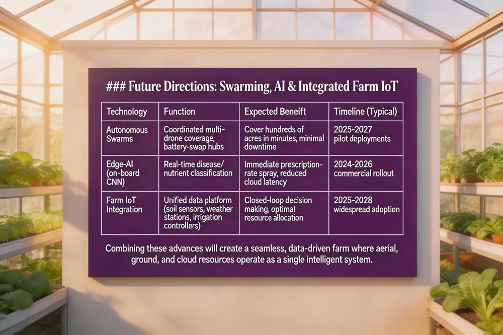 The next wave of agricultural UAVs will move beyond single‑craft missions to coordinated swarms that can cover hundreds of acres in minutes while a ground crew swaps depleted batteries. Researchers are prototyping autonomous‑swarm algorithms that assign each drone a sub‑field, monitor battery health, and land at a charging hub for rapid battery exchange, keeping the fleet aloft with minimal downtime. At the same time, edge‑computing chips are being integrated into drone payloads, allowing real‑time image analysis and disease classification without relying on cloud latency. Multispectral and thermal cameras feed convolutional neural networks that flag early signs of fungal infection or nutrient stress while the drone is still overhead, enabling instant prescription‑rate spraying. Finally, drones are being wired into broader farm IoT ecosystems: data streams from soil‑moisture probes, weather stations, and smart‑irrigation controllers converge in a unified platform that synchronises flight paths, variable‑rate inputs, and alerts. This seamless interoperability promises a closed‑loop, data‑driven farm where aerial, ground, and cloud resources act as a single, intelligent decision‑making system.
Conclusion
Modern agricultural drones provide imaging, multispectral and thermal data, and precision‑spraying capabilities that let growers monitor plant health, detect water or nutrient stresses, and apply chemicals only where needed. These tools boost yields, cut water and chemical use, lower labor costs, and improve worker safety, while complying with regulations such as FAA Part 107, Part 137, and Ireland’s EU‑derived drone rules that require registration, pilot certification and altitude limits. For Irish farms, speed means scouting, pest‑drift mitigation, integration with GIS platforms. Tidesmit supplies controllers, accessories and services that simplify adoption and keep growers within legal parameters. Embrace these precision‑agriculture technologies today now to stay competitive and sustain the countryside.